Wednesday, July 31, 2013

Day 28: Bull Branch Campsite to Carlo Col Shelter

Today's Miles: 7.1
Total Miles: 281.3

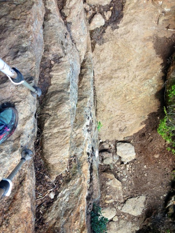
Mahoosuc Notch. I had been dreading this day for weeks. Dr. Evil and I were on the trail by 6:30, ready to tackle the challenge that lie ahead. And honestly, it wasn't all that bad. This 1.2 mile section of boulders is often referred to as the hardest mile on the entire trail. Some look at it as the most fun. It was a challenge and took just under 2 hours to complete. I only had to take my pack off once so I could lift myself up on a tall boulder. I managed to squeeze if through and wiggle my way through all of the tight crevices and crawl spaces, which surprised me. There was a point near the end where ice could be seen underneath the rocks, hiding from the sun. It was a mile of climbing, crawling, jumping, and careful stepping. Each move had to be well calculated as it was fairly technical boulder scrambling, and a wrong move would lead to a pretty good fall in some areas. The area was predominantly flat, and I feel that made it much more manageable. Had it been an uphill climb, it would have been another story. I was certainly spent after it was complete since I used muscles that I haven't in a while, and I'm glad I only planned a short day for the remainder of it. We had a few mountains after the Notch - Fulling Mill, Goose Eye, and Mount Carlo. I thought some parts going up and down Goose Eye were honestly more difficult than the Notch, but maybe being tired at that point had some influence on that. The views today were incredible, and that always makes for a great day. Some parts of the mountaintops were covered in meadows, and I was just able to follow a bog bridge along the trail with beautiful open views all around. There were mountains as far as I could see on all sides. Incredible. I enjoyed my lunch on Goose Eye and continued on to the shelter. I was so amazed by today, I wasn't even upset there was still another climb up Mount Carlo. I met Dr. Evil at the top with Bird Nut, a man who has amazingly completed a Continental Divide, 2 Pacific Crest Trail, and 2 Appalachian Trail hikes. Simply astonishing. The shelter was a short hike down, and it was nice and early when we got in. It was probably the earliest day I've had so far. It was nice to be able to relax. I'll be doing 2 more short days to Gorham so I won't have to take a zero there. Dr. Evil planned on hiking 12 miles today and 12 into Gorham, but I somehow convinced him otherwise. I find it a little ironic since I'm usually the one pushing people to head into town, not stay out of it. I'll be in New Hampshire in a half mile tomorrow, and I can't wait for my first state line! 

In the notch. So many rocks. 

Tight squeeze

Careful navigation was key

Ice in July!

A little crawl-through

Made it through!

Mountaintop meadows and bogs

Tough climb

Found this poor little baby bird next to the trail. I think he fell from his nest, but didn't know how to fly yet. I wish I could have helped him. 

On top of Goose Eye

Vertigo

Straight down

Day 27: Grafton Notch to Bull Branch Campsite

Today's Miles: 7.0
Total Miles: 274.2

It feels great to be back out here on the trail, even though it felt like everything was trying to keep me from making it back out yesterday. I left New Hampshire with my brother around 12:30 and had to stop at EMS for a new spoon since mine grew legs and walked away sometime over the weekend. About halfway through the 3 hour drive, I realized I had left my rain jacket. It was too late to turn back at that point so I asked my brother if he minded stopping at the outfitter in Bethel since we drove that way anyway. He agreed, so we stopped and I got another jacket. My original plan was to hike to Speck Pond and camp there for the night, but it was almost 5 miles away and already past 5:00. I called The Cabin and decided to stay there for the night instead. After being there for a few hours, I had another revelation. I forgot my spoon in my brother's car. I couldn't believe it. So now I'm rocking a normal spoon until Gorham, where I hope to trade it back in for a new one. 

I started today with another great Cabin breakfast and was even able to take some blueberry pancakes for lunch. I waited for the other hikers heading to East B to get ready and was shuttled back to Grafton Notch. It was a later start, but I knew it would be a short day so I thought I still had plenty of time. I thought it started off nicely, but the ascent got annoying since it was hard to determine where the summit would be, and the trail in this area is poorly marked. At some point on the climb up one of my shoelace loops broke off, so It looks like I will now be sending those back in Gorham. I've been through 2 pairs of shoes and haven't even hit 300 miles yet. I stopped for lunch before reaching the point where the trail split for Old Speck Mountain. It was a nice viewpoint, so I called Payce, ate my pancakes, and enjoyed how the sun felt. I was sitting there when Dr. Evil walked up, which I was very surprised to see. He had taken a few zero days in Andover, and it was nice to see a familiar face. Two other gentlemen came up shortly after with their yellow lab. He was such a happy puppy, and I wish I could have taken him with me! It made me miss my Dexter more. Dr. Evil and one of the other men started to debate about the Civil War, the government power, states' rights... They asked if I learned anything from their discussion. I told them I learned never to stick two attorneys on the top of a mountain together. Dr. Evil and I continued to hike together for the rest of the day. There were some very tricky descents, and we were making very slow miles for the rest of the day. We stopped at Speck Pond for a break, which was a beautiful spot, and then had to go up and over Mahoosuc Arm. I realized then that I had lost my Nalgene bottle somewhere in the downhill. I'm glad I brought a small Gatorade bottle back out with me, or I'd have had no means of treating my water. I passed some NOBOs earlier who said the water at the campsite wasn't very good, so we ended up getting water at a source that was very brown, thinking it was our last chance. So wrong. There was another stream a short way up from the campsite, and the water was fine. I had carried 3 liters of water that whole way for nothing. I got to camp a little after 5:00, set up, talked to Dr. Evil for a while, and ate dinner. He wanted to see what music I had on my phone, so we conversed about that for a while. It looks like I'm back to my 8:00 bedtime, as it will be just past that when i finish this and turn in for the night. We start off tomorrow with the Mahoosuc Notch, which will set the tone for the rest of the day. 

I just want to send out a BIG thank you to my brother for carting me back and forth this weekend. I really can't thank him enough. Also, one goes out to the friends who take me in whenever I randomly drop in, which has been a lot lately! The trip back to NH this weekend would not have been possible without them. 

Also, I unfortunately had to hear about the missing hiker, Geraldine "Inchworm" Largay while I was in NH. If anyone has any information, please do what you can to help! 


The view on the way down Old Speck

Speck Pond

Whoever looked at this and decided it would be good to put a trail here is not my favorite person right now. This wasn't even close to the worst part we descended today. 

Monday, July 29, 2013

Day 26: East B Hill Rd to Grafton Notch

Today's Miles: 10.3
Total Miles: 267.2

Today was the day my brother would be picking me up from Grafton Notch so I could head to New Hampshire for a bridal shower this weekend. Ideally, I would have already made it to Gorham, but it didn't work out that way. I'm so thankful my brother was willing to make the trip up. 

I left The Cabin before breakfast so I would have plenty of time to hike the 10 miles before 3:00, when he was expected to be there. I started a little after 7:00 and took advantage of the time, a little too much apparently. There was a lengthy ascent for about 3 miles that seemed never ending, especially since my calf muscles have been cramping quite a bit the last 2 days. I stopped at the first lean-to for a snack, and it decided at that point that it would start raining. This made for a slick and slow climb up Baldpate, more so when I reached the open rock face near the top. I made a call to my brother at the top since the rain put me a little behind schedule. I had just over 2 hours to go 4 miles. There was a small sliver of a view on top of the east peak, but the clouds were moving in to cover it quickly. Soon enough, I was engulfed in a rain cloud and sliding my way down towards the west peak. I made a quick descent and still made it the Grafton Notch parking lot just before 3:00. Still on time! The descent wasn't too challenging - there were a lot of rocks steps, and I couldn't even fathom the manpower that went into their construction. I was happy to see it become a gradual, easy descent after the number so steps declined. I talked with Cool Blue, Sherpa, and Google for a little while before they moved on to Speck Mountain. My brother made it, and we made the trip back home. Goodbye for a few days, trail! See you again on Tuesday. 


Falls at Dunn Notch


Some of the climb up Baldpate

Rain clouds moving in

In a cloud


Thursday, July 25, 2013

Day 25: South Arm Road to East B Hill Road

Today's Miles: 10.1
Total Miles: 256.9

I was able to experience slackpacking for the first time today. I enjoyed a nice Cabin breakfast (courtesy of Earl) and started hiking around 8:30. Shuffle was at the trailhead and decided to partake in the slackpack as well. We arranged for a pick up at the other road crossing into Andover at 3:00. It was a fairly uneventful day of hiking a few good climbs over Moody, Hall and Wyman mountains. It was still incredibly muddy from the previous days' rain, and of course I didn't make it through without slipping in the mud and laying completely out a few times. When I got to the first lean-to, everyone was stopped for a break, and I'm sure it will be my last time seeing the whole group together since I will be heading back to New Hampshire for the weekend. I hope to cross paths with them at some point in the future. I did see MDot a little further down the trail, who was hiking some with his wife and grandson. I listened to some music to help pass the less interesting miles. I reached the road about a half hour before the pickup time, where Delta was trying to hitch a ride. I told him about the shuttle, so we had lunch and waited for Shuffle and the shuttle to arrive. I was able to see MDot and say goodbye. I came back to The Cabin for one last afternoon and packed my bags in preparation for Grafton Notch tomorrow. I'll miss The Cabin and the great people here. They are so welcoming and hospitable. It's good to see people like this still around. 


Grouse in the tree


Surplus Pond

Wolfbird in his sweet town clothes

Found this tacked at the road crossing with my phone charger. Some confusion at The Cabin. Thanks for not taking it, Live Simply!

Wednesday, July 24, 2013

Day 24: Andover


Today's Miles: 0.0
Total Miles 246.8

Today was a much needed zero day. It gave everything a chance to dry out, including my raisin fingers and toes from yesterday. My feet were a disaster after wet shoes all day, and all my blisters just separated from the skin underneath completely. It was a mess. MDot's wife and grandson came into town from Florida, and it was great to be able to meet them. We went to Bethel so everyone could resupply and I could get my broken hiking pole fixed. It was a cute town and offered a lot more in terms of food than Andover did. It would have been nice to stay there. Tomorrow I'll be staying close to town and doing a day of slackpacking. This consists of hiking with only a day pack instead of all my gear. I will be dropped off at the start and picked up at the end of the day. I'll come back and stay here at The Cabin for another night after that. Live Simply and Uno will be moving on tomorrow, so hopefully I see them along the way somewhere down the trail. 


Live Simply crushing up some Ramen

Uno and Live Simply packing up for the next leg of their hike

Day 23: Bemis Mountain Lean-to to Andover (South Arm Road)


Today's Miles: 8.7
Total Miles: 246.8

I knew the moment I heard rain drops on my rain fly that today was going to be an interesting day. I grabbed my clothes hanging outside as soon as I realized the situation and dragged out the process of getting out of my tent as much as possible. I finally started hiking just before 8:00, and the rain was constant throughout the entire day. There was mud everywhere, and avoidance was nearly impossible. I slipped into one mud pit and ended up being to my knee in mud. Wet roots are the devil. I slept on one and fell face first. A pine tree was nice enough to break my fall before I had a chance to completely catch myself. The original plan was to hike 12 miles to the lean-to and head into Andover tomorrow. That plan was quickly thwarted, especially once another steep climb up the next mountain was considered. I passed a few other hikers throughout the day who were planning on going into town, so I was hoping to catch a shuttle with them. There was a steep descent down Old Blue Mountain that proved to be slippery, and an even steeper one down to South Arm Road. I slipped in some mud on a narrow switchback and really thought I was a goner. There was nothing over the edge, and it was too foggy to see what was down at the bottom. I didn't know if it was water, the road, or just more mountainside. It was a long, slow climb down. When I reached the bottom, Rerun was there with some NOBOs waiting for a shuttle. Dr. Evil and Hal showed up shortly after, and we were all able to squeeze into the van and head to town. One of the people from Pine Ellis picked us up, but they didn't have any more room at their place. I kept trying to ask where The Cabin, another bunkhouse, was, but I was being ignored. At this point I was cold, soaked, and irritated so I gave him his money for the shuttle just so he would leave. I called The Cabin from the general store, and Earl came to pick me up a few minutes later. They were pretty much full, but still let me come anyway. I slept on the couch, but couldn't have been happier with the decision. MDot, Live Simply, and Uno were here when I walked in, which I was surprised to see. I guess they got tired of the rain today too. We all made the right choice - there were lobsters and steak for dinner tonight and moose tracks ice cream for dessert! This place is amazing and I'm so happy to be staying here. 

This was supposed to be a viewpoint. 

Normal trail food?

Moose tracks and brownies!

Day 22: Little Swift River Pond Campsite to Bemis Mountain Lean-to

Today's Miles: 12.9
Total Miles: 238.1

I woke up very cold this morning and dreaded getting out of my sleeping bag. I ate my breakfast by the pond with the hope of seeing a moose. I didn't, of course, but Uno and Live Simply said one showed up right after I had left. So typical. The hike today didn't start off too bad. It was fairly easy terrain - a few small hills and some mud here and there. One of my hiking poles broke going down a hill. The bottom just decided it felt like falling out, but there is an outfitter in Bethel that does repairs on them. Uno and Live Simply tried to help fix it when they passed by, but it's just being held together by duct tape right now. At least it only has to make it a day and half until town. I stopped by a pond for lunch, where Dr. Evil and Rerun were passing by. They stopped for a bit too, and I continued hiking with them until they reached the campsite they were staying at. I still had about 3.5 miles left at that point, so I continued on. I had to start climbing Bemis Mountain to reach the lean-to, but it took much longer than it should have. Why, you ask? Blueberries. I can't pass by a blueberry bush without grabbing a few. I'm surprised I don't look like Violet from Willy Wonka and the Chocolate Factory yet. It wasn't until I passed a few people that were part of a Boy Scout troop that I realized I had to get my act together and hurry up. Thankfully, they saved me a spot so I didn't have to throw down over a tentsite with any Boy Scouts tonight. Thanks, guys! I've also learned today that you can never trust a NOBO when they say "You're close to the lean-to," or "You're almost there." Their perception of distance is much different than mine at this point. It's going to be a cold night and even colder morning. We're staying at almost 3000 feet elevation, so I just might be sleeping in tomorrow. 

Since I saw moose trucks in the mud yesterday and today, all I can think about is Moose Tracks ice cream. Hurry up, Andover! I need some!

Tacked-on white blazes

Just a random boulder field

At least the day ended better than it started!

2nd Peak of Bemis Mountain

Monday, July 22, 2013

Day 21: Poplar Ridge Lean-to to Little Swift River Pond Campsite

Today's Miles: 15.5
Total Miles: 225.2

Today was by far the best day after Katahdin on the trail. After an obnoxious night at the lean-to with some unnecessarily loud NOBOs, I thought I would be the ultimate grump today. I was VERY wrong. 

It started off a very cold morning. I could even see my breath. But if a cold morning means I get a nice cool day for hiking, I have no complaints. Since I stopped early yesterday, I had 3 summits today - Saddleback Junior, The Horn, and Saddleback Mountain. The views couldn't have been more beautiful. As I reached the summit of Saddleback Junior, I was able to look out and see clouds passing by the mountains below me. It was an incredible feeling being above the clouds. The descent and ascent back up The Horn was long and below the tree line, but manageable. It was nothing that I haven't come to expect from a climb on the AT thus far. After the Horn, it was all above tree line with incredible views to Saddleback. It could not have been more perfect. The wind was cold, but I was thankful for such a beautiful day. I stayed on top on Saddleback Mountain for close to an hour and a half making a few calls and talking to a few NOBOs. I always enjoy getting other perspectives on the trail ahead. There were also a lot of day hikers on the trail today as well. It seems like a very popular ridge to hike. I had to head down because I was getting too chilled on the top, so I continued to a stream for lunch. I made it down a little bit quicker in some parts by using the butt-slide trick. It's just the easiest way to get down some of the steep rocks. I wanted to eat everything in my food bag today for some reason, but I was able to restrain myself. The rest of the trail was very nice today. I was able to make up some good time. I stopped at the Piazza Rock Lean-to to sign the register and seriously considered staying. It was a beautiful shelter and had some great tentsites. I decided to continue on. I crossed the highway and was able to resist the draw of the trail town, which was surprisingly satisfying. A lot of other hikers kept saying we needed to stop in Rangely because it's a great little town, but I really had no need to. I know a lot of the hikers at the lean-to last night headed into town. I made it the last 5 miles into the campsite in about 2 hours. I'm ready to sleep in my tent again after 2 nights in lean-tos. MDot, Live Simply, Uno, Hal, Kelty, Flicker, and some other NOBOs are here. Everyone was pretty much already in their tents when I got in. I also have to add that I'm thankful for the higher elevations and cooler weather. The bugs have been so much better the last few days. I'm hoping we'll see a moose by the pond in the morning. I saw a lot of tracks in the mud on my way in.  

Above the clouds

Well, this makes it easier!

The Horn and Saddleback from Saddleback Junior

Saddleback Mountain


Another ladder


The pond at the campsite tonight

Day 20: Spaulding Mountain Lean-to to Poplar Ridge Lean-to

Today's Miles: 8.0
Total Miles: 209.7

After the tough, rocky climbs yesterday, I really couldn't push myself through the last 3 miles to the campsite today. I was exhausted, and my hips were aching from the unexpected climbs today. There was a rock that took me about 10 minutes to find a way up. If I had pushed on past the lean-to, I would have had another steep climb up Saddleback Junior before making camp. There were a few climbs today, but none that offered a good view. Most were covered by trees except for a small opening on Poplar Ridge. There were a few nice stream walks and a small stream ford that made some of the miles a little bit more enjoyable. Tomorrow will start with some tough climbs in the morning, but it looks like it will level out some going into Rangely. I made it into the lean-to around 2:00 today, and Peter and Delta are staying as well. They started a fire that smoked me out of the corner of the shelter for a little while. There was a quick rain shower that passed through this afternoon, and a few hikers stopped here until it finished up. I was thankful I wasn't caught in it while hiking uphill. Hopefully this will be the last of the rain for a few days. 

Perham Stream

View from Poplar Ridge - dark clouds overhead