Saturday, August 10, 2013

Day 35: Lakes of the Clouds Hut to Ethan Pond Campsite

Today's Miles: 14.1
Total Miles: 348.3

I didn't wait for breakfast at the hut this morning so I could get an earlier start on the day. I ate my oatmeal and headed out on the beautiful stretch of trail that lay ahead. I was enjoying the unspoiled beauty, listening to the birds sing as I continued along. My energy level diminished quickly, so I found a rock to lay on by Mount Eisenhower and mixed up some Crystal Light Energy. I enjoyed the sun while I waited for the caffeine to kick in and continued on. Maybe I should take up coffee drinking. I walked around Mounts Monroe and Eisenhower and up Mount Jackson, stopping for a quick break at Mitzpah Hut. On the top of Mount Jackson, I decided to have lunch, again admiring the incredible views. I'm going to miss moments like this further south. There was a section that followed along Webster Cliffs with beautiful openings all along the way looking into Crawford Notch. I made some phone calls while I stopped for a break but had to keep pushing on with so many miles left. I finally made it into the notch, which was probably the nicest descent I've had into one.There were some steep descents in some areas, but they were short and followed by some nicer trail sections. I crossed the Saco River, which offered some very tempting stealth sites, but continued on across the road. There was a short section of trail that followed the road, and I find it amazing how difficult it feels to walk on a road after being on dirt and rocks all day. I made it the last 3 miles in about an hour and a half, and I always think that if I could move that fast all day it would make the days so much shorter. I set up my tent and talked to the caretaker at the site for a little while. She was very friendly, and it's always interesting to hear what brings them out here. She was studying sustainable living and was interested in water conservation. She said there was a beautiful sunset down by the pond, so I rushed to set up and cook dinner so I could see it. It was pretty amazing. For some reason, all day I was thinking I only had to go 12 miles to the campsite, but now that I've done the math it turned out be 14. Oops! I guess now I don't feel so bad about being so slow today. Now it's off to bed so I can prepare for another great day out here. 

You can't be upset when this is how the day starts off. 

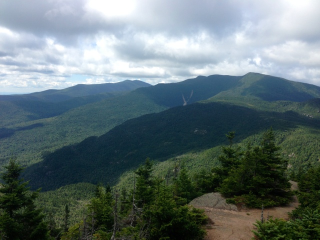
Looking back from Mount Jackson

Mount Washington swallowed by a cloud

Webster Cliffs

Looking at where I just was from the bottom always amazes me. 

Sunset at Ethan Pond

Day 34: Osgood Tent Site to Lakes of the Clouds Hut

Today's Miles: 10.1
Total Miles: 334.2

I was kept up a good portion of the night by shooting pains throughout my legs that would not let up for anything. Any way I tried to move was painful. I still woke up feeling much better than I did starting out yesterday, but I also slept in until about 6:30. The hike today started out great. It was about 2.5 miles to the top of Mount Madison, where it quickly entered the alpine zone and went above tree line. From there, it was all rocks and boulders for the rest of the day. This would become old quick and was a little tough to deal with for almost 10 miles. I stopped for lunch at the Madison Spring Hut. There were a father and son stopped for a break as well, so I talked to them for a little bit. They offered me a homemade strawberry oat bar, which I gladly accepted. It was pretty delicious. I continued on, making slow progress for the rest of the day. I took the best fall of all today, and I was so glad no one was there to witness it. I somehow fell forward, but on my side. My left arm was extended behind me but pinned under my pack, so I couldn't wiggle it free. I was just laying across the trail, completely stuck until I could roll enough to be able to push myself up with my right arm. I felt ridiculous and just sat on the trail for a minute while I recovered. I still don't understand how I haven't broken anything yet. The trail today skirted around some of the climbs, including Mount Adams, Jefferson and Clay. I'm glad the trail here is different from Maine in that aspect. If there was a mountain in sight in Maine, it was almost a guarantee that you would be going over the summit. The trail didn't skip Mount Washington, however. I  somehow ended up taking the wrong trail, which brought me around the mountain instead of over. I had to backtrack and find my way back up to the right trail, which took too long since I was already grouchy, and it was getting later in the day. I could also feel some blisters forming on the arches of my feet from all the fun (sarcasm) climbing on rocks. I eventually made it to the summit, grabbed a bite to eat, and headed to the hut. I was lucky enough to get Work For Stay here, and I was genuinely surprised considering how late I was getting in. The whole hut system reminds me of a bizarre summer camp, but meant for adults and kids. There are set meal times and menus, lights out time, quiet time, and a morning wake up. It's all just odd to me, including the fact that people pay so much to not have a shower and sleep on a bunk bed. I definitely don't mind staying for free, even if it means I have to clean out the fridge. I'm hoping tomorrow will offer some of the same unmatched and breathtaking views that I had today. The only problem is that it takes so long for me to hike when I want to take pictures of everything!

The start of the Presidential Range

About 9 miles of today's trail...rocks!


A few years ago I was on this train taking pictures of people hiking up. It was surreal to have a complete role reversal today. 

A perfect day on Mount Washington


It's crazy to think I've made it 332 miles. 

Lakes of the Clouds Hut

Day 33: Carter Notch Hut to Osgood Tent Site

Today's Miles: 10.9
Total Miles: 324.1

Oh, to wake up warm while the wind tries to sneak through all the cracks and crevices of the windows and the doorway is a beautiful thing. Waiting in a cold shed with the door tied shut while everyone else eats their breakfast isn't so great, but at least there were pancakes after to make that part a little bit more tolerable. I guess that's all a part of being a thru hiker. I hung around the hut far longer than I should have this morning, but it was so cold I had no motivation to leave any sooner. The NOBOs staying there offered to do the morning chores of cleaning the bunkhouses, but I felt bad bailing so I stayed to help. I was seriously contemplating going back into town for the night because it's supposed to get pretty cold, but I resisted the temptation. It really would have messed up the mileage I had planned for the next few days too. There, it's supposed to be in the 40s, and since we're almost 2000 feet higher in elevation, I would be surprised if it's much above freezing in the morning. I can't believe I'm saying that at the beginning of August. It just doesn't seem right. Today was a tough day. I averaged about a mile an hour for the first half of the day. It started off with a climb up to the Wildcat Range. It was one of those days where it was perfect weather if you were moving, but too cold if you stopped. I called Payce at the observation tower on top of one of peaks since I was in a weird mood and couldn't figure out which trail to take down. My body just didn't feel like hiking today. It seemed like it was taking forever to get anywhere. I had an incredibly steep descent not too far ahead that I was dreading. I'm learning that heading down into the notches is terrible, and the going back up isn't very fun either. The last mile heading into Pinkham Notch wasn't too bad. It leveled out and began following around some ponds for some time. I met a family that was out for a few days, and they were very interested in the hike. It was nice to talk to them about it for a little while. It made me feel better after I was scoffed at by a NOBO for wearing earrings today. I stayed at the Pinkham Notch Visitor Center for about an hour and enjoyed a good meal before deciding to move on. I think I still had about 4.5 miles left and was able to get through them in about 2 hours. They were nice miles. Some parts reminded me a lot of the 100 Mile Wilderness. It got frustrating a few times when I was trying to figure out where I was because there were at least 10 stream crossings, whereas the book only showed 2. Since it was already pushing 7:00 and I was trying to race the setting sun, I had no way of pinpointing where I was. There were also no blazes anywhere on the trail for the last few miles. It became very frustrating and a little unnerving, especially since the trail right out of Pinkham Notch was marked exceptionally well. I finally found the tent site, which turned out to be already full. I found a small level spot that I could squeeze into, which ended up being near Icepack. I didn't know it was him until I asked if he minded if I put my tent nearby (he was in his hammock at the time). It looks like most of the others here are NOBOs. I'm all ready to be curled up in my warm sleeping bag and hunkered down for a chilly night. I do have to add that today was the first time I didn't have to bandage any blisters, and I was still blister free at the end of the day. Hopefully the pain persisting in my hips right now will be gone by the morning.   

The pond in Carter Notch with the Wildcat Range behind it

Mountains in the clouds 

The Gondola on Wildcat

Heading into Pinkham Notch

Crossing the Mount Washinton Auto Road. This is how I got up to the mountain the first time when I was a kid. 

Peabody River

The cable bridge over the river. I felt exactly like those movies where a board breaks and someone falls. I think I held my breath the entire time. 

Day 32: Rattle River Shelter to Carter Notch Hut

Today's Miles: 13.0
Total Miles: 313.2

There were a lot of reports from the NOBOs about today's hike being a difficult one. I was a little nervous about putting in some good miles since I haven't done over 10 in too long. I started with the ascent of Mount Moriah, which wasn't terrible, just long. I felt a few drops of rain before I reached the top, but by the time I was up it had started to clear. There were some incredible views, and I could see where the rain clouds had moved past me. I thought I might be in luck for the rest of the day. I continued to Imp Campsite, where I stopped for a quick lunch break before continuing up the Carter Mountains. There was a tricky spot that required a lot of climbing and scrambling, and just then it started to rain again. But this rain was much more persistent. There were a few day hikers caught in the rain completely unprepared. As I descended down Middle Carter Mountain, I began to see the rain start bouncing. HAIL?! You have got to be kidding me! As if the rain wasn't bad enough. Icepack passed me shortly after, which I was surprised to see. He had planned on stealthing in Zeta Pass, but said it was too early to stop hiking. He wanted to go to Carter Notch Hut as well, where I was hoping to be able to do work for stay. I told him he better not steal my spot, kind of joking but there was probably a bit of seriousness to it as well. As I climbed over Mount Hight, I thought I was going to have to crawl on my hands and knees because of the wind. I started to get pelted by hail again as I reached the open summit. It was a good thing Icepack was waiting at the trail leading back down because there was a good possibility I would have been lost. There were cairns everywhere so I was looking every which way trying to figure out where I needed to go. After that, it was a tough descent down to the notch. It was only a mile but took almost an hour to get to the bottom. When I got into the hut and asked if they had any work for stay spots still open, they said they only had one. Icepack let me take the last spot (thank you SO much). The AMC owns a series of huts in this part of the White Mountains. Most guests pay over $100 a night for the accommodations, but they usually allow a few hikers the opportunity to put in a few hours of chores and are then allowed to have leftovers at dinner and breakfast and sleep on the dining room floor. After arriving, I quickly washed up and changed into dry clothes. Everything was drenched from the hike today, and since we are just shy of 4000 feet elevation, it was cold! There were 4 NOBOs staying here and one other SOBO. Our chores consisted of organizing the outdoor food storage, which has now become our shelter when we are waiting for everyone to finish their meals. We aren't allowed to wait inside while the guests eat, and this is the warmest place we could find. We were invited in after a few hours and had some wonderful stuffed shells, soup, and carrot cake. I think it may have been worth the wait. We are now waiting for the rest of the guests to head to bed. There are a few kids here playing a game that aren't really getting the hints the croo (the group of workers at the hut) are giving. I can hear the wind howling outside, and I'm so glad to be inside tonight. I hope this is not an indication of what the rest of the Whites will be like. 

Descending Mount Moriah

Lunch time - found some great white chocolate peanut butter in town, which has proven to be a nice treat.

Rain in the distance 

The first sight of the hut in the notch. Still a long way to go. 

The view as we descended into the notch

Day 31: Gorham to Rattle River Shelter

Today's Miles: 1.9
Total Miles: 300.2

Maybe I should have just stayed in town today, huh? BUT I did hit the 300 mile mark, so I guess it wasn't for naught. And I saved a few dollars, so that is bueno as well. I did intend to put in 8 miles today, but by the time I left it was already 1:00. The day started off with a great homemade breakfast consisting of an egg casserole, oatmeal, muffins, and hash browns. I then had to wait for a shuttle to town so I could mail my broken shoes back home, and I wasn't exactly moving with a purpose when it came to getting the rest of my stuff ready. The first part of the trail was beautiful again today - a nice gradual incline that followed the river for a portion of it. I got to this shelter in just over half an hour, but it looked like the clouds were moving in at that point. I decided to stay put, afraid of trying to make it over the mountain in a thunderstorm. It only ended up sprinkling a little bit here, but I'm still pretty sure it would have poured had I decided to continue on. There's a group of NOBOs staying here, but most of the SOBOs were staying at the lodge for another night. It's not too bad here. The Rattle River runs right by the shelter and would have been a great place for a swim had it been warmer. Grandpa, a NOBO from Massachusetts has been the fire keeper for the night. After talking to him for a little bit, I had to ask where he was from. I knew it was New England somewhere. He's like so many of the people that I met growing up there. I think I'll be calling it an early night. I'm still pretty exhausted even though I slept amazing at the lodge last night. 


Rattle River

300 miles!

Saturday, August 3, 2013

Day 30: Trident Col Campsite to Gorham

Today's Miles: 6.9
Total Miles: 298.3

I woke up this morning eager to head into town. I didn't sleep well last night, and when I woke up at 4:00 I realized it wasn't nearly as light as it had been a few weeks ago. I went back to sleep until about 5:15 and slowly started gathering my things. The rain had stopped during the night, but the trees were still making it seem as if it was persisting, dropping water with every gust of wind. There are few things that I hate more than packing up wet gear. It is all just a muddy mess and adds even more weight to my already too heavy pack. We finally got moving and were back on the trail by 6:40. Icepack caught up to Dr. Evil and I shortly after we left. I was in front, and the day started off with a climb up to Cascade Mountain. It was short and steep to the first viewpoint, which of course was nonexistent today due to the rain clouds surrounding us. It leveled out over the top of the mountain for some nice easy hiking. There was a lot of underbrush hanging over the trail, and my shoes and pants were drenched within the first mile. At that point, I just kept charging forward. There was a point on Cascade Mountain where the trail went up one way and seemed to turn around to run almost parallel to that section again. I wouldn't have realized it if I didn't hear Dr. Evil and Icepack coming up the section I had just been on. I was a little confused and didn't really understand why it was necessary since the point where it turned was nothing substantial. I headed down this mountain and was faced with a nice ascent up Hayes Mountain. It had started raining again just before I began the climb, but at that point I don't think I could have cared less. As I reached the summit, the rain had stopped and I could see blue skies trying to make an appearance - a beautiful sight. There were so many sections of incredible trail today, and I couldn't remember the last time I had seen trail that wide and smooth. I stopped for a snack by a brook and waited to see if Dr. Evil and Icepack would catch up, but I just kept pushing in to town when I heard nothing. I had to walk along a few roads today, which is always a little weird to me after coming out of the woods. I had reservations at The White Mountains Lodge and Hostel, and I don't regret staying here one bit. This is the cleanest and most kept-up hostel I've stayed in so far. The owners just changed last week, but the new ones are doing an outstanding job keeping the place running smoothly. I didn't even have to do my laundry. They did it for me! I showered and headed into town in search of some replacement shoes. I got lucky at the Hardware and Sports store (I'm still baffled by this store concept). Hopefully these Merrells will serve better than the last 2 pairs have. In less than 300 miles I've been through 3 pairs of shoes, 3 rain jackets, and 3 spoons. Unbelievable. We were shuttled to the Wal-Mart in town for resupply later in the evening, and I just finished packing my food for the next stretch. Tomorrow I will be heading back out after sending my old shoes back home, weather dependent. I have a huge climb up Mount Moriah tomorrow, which will not be a wise undertaking in a thunderstorm. 

I'll take rock steps over steep rock faces in the rain any day. 

It's hard to believe this was part of the trail today. Beautiful!

This reminded me of the road I grew up on, minus the houses. 


Apples on the roadside

Dark clouds moving in

I can shamefully admit I ate this entire pint of Ben and Jerry's in one sitting. 

My old buddy, the Hoff!

Here's to hoping these last a bit longer than the last two pairs did. 

Friday, August 2, 2013

Day 29: Carlo Col Shelter to Trident Col Campsite

Today's Miles: 10.1
Total Miles: 291.4

I'm home. Well, kind of. I finally crossed my first state line and headed into New Hampshire today. I've been waiting for this moment for 281 miles, but I don't think Maine was ready for us to leave yet. As soon as we headed out of the shelter, we were faced with a large boulder scramble going uphill - the worst! Being only a half mile away from the state line was motivation enough to get up and get through it. When I finally saw the sign, I was elated. I reveled in the moment, thinking of how far I've already come, but still humbled by how far I still have left to travel. We were immediately greeted with an ascent up Mount Success, the first mountain in a new state with an appropriate name, I thought. It was a beautiful spot for a break, and since I was already hungry, I pigged out. I'm still terrible about packing too much food, so when I know I still have a ton left over and I'll be in town the next day, I tend to go a little overboard. The terrain today was much easier than the last few, but I still hurt quite a bit by lunch. I was glad to be doing another short day. For some reason, my pack tore up my back today too. Now I have raw spots all over my lower back, and I'm a little perturbed by it. I've had no other issues with it the entire hike. At least tomorrow will be a short day into town and maybe it can breathe some, although I don't think the rain expected in the morning will help much. The number of SOBOs I've seen recently has dwindled significantly. I met another one at the campsite tonight that Dr. Evil knew, named Icepack. I wonder how many more are behind us. It has already started raining tonight, so here's to hoping I can stay dry! 

Hey, New Hampshire!


On top of Mount Success

One would think that after almost 300 miles, I would be able to make it down a rock without wiping out. Nope!

Reflections on the pond


Raindrops collecting on my rainfly